

Updated November 20, 2026, 3:11 p.m. ET
- A magnitude 4.4 earthquake struck near Commerce, shaking the Los Angeles area early Friday morning.
- There were no immediate reports of significant damage or injuries following the quake.
- The Los Angeles Fire Department activated its earthquake response protocol to survey the city for possible damage.
- Authorities reminded residents to prepare for possible aftershocks and follow safety instructions.
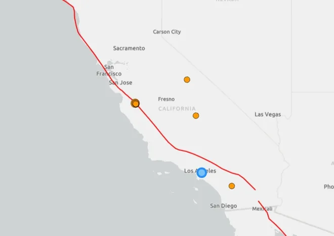
A magnitude 4.2 earthquake shook the Los Angeles area early Friday, Nov. 20, waking up Southern California residents after a tremor struck near Commerce.
The earthquake occurred at 3:25 a.m. Pacific Time, with an epicenter about 1 mile northwest of Commerce, according to the U.S. Geological Survey. The earthquake struck at a depth of approximately 10.6 miles.
The tremors were reported across a wide area of the Los Angeles basin, including in communities well beyond the immediate epicenter. More than 7,500 people submitted reports to the USGS describing the shaking in the first hour.
No structural damage or injuries were initially reported, according to the Los Angeles Fire Department. The department activated its earthquake response protocol, dispatching personnel from all 106 neighborhood fire stations to survey the city’s 470-square-mile jurisdiction for potential damage to critical infrastructure and other areas of concern.
The department said the assessment typically takes less than an hour and asked residents to prepare for possible aftershocks.
Where did the earthquake hit near Los Angeles?
The epicenter was about 1 mile northwest of Commerce, near East Los Angeles and about 5 miles southeast of downtown Los Angeles, according to the U.S. Geological Survey. The earthquake was felt throughout the Los Angeles metropolitan area, with reports extending to communities including Pasadena, North Hollywood, Gardena and Riverside, among others.

Could there be aftershocks?
Aftershocks are possible after an earthquake, and Los Angeles firefighters urged residents to stay prepared. If another earthquake occurs, officials recommend following Drop, Cover and Hold On guidelines. People indoors should hide under sturdy furniture or near an interior wall, protect their head and neck, and stay in place until the shaking stops. The USGS is also encouraging people who felt the earthquake to submit reports through its Did You Feel It? system, which helps scientists assess the intensity and geographic scope of earthquakes.

Can we predict earthquakes?
According to the U.S. Geological Survey, scientists currently cannot predict earthquakes accurately enough to say when a major quake will occur, where it will occur, or how large it will be.
The US Geological Survey says neither it nor other scientists have successfully predicted a major earthquake, and reliable earthquake prediction is not expected to become possible in the near future.
Instead, scientists monitor seismic activity, study faults, and calculate earthquake probabilities to better understand the risks communities face.
Why are earthquakes so common in California?
California is located on the border between the Pacific plate and the North American plate. The plates are constantly moving against each other, creating tension in the Earth’s crust.
When this stress overcomes friction along a fault, it can suddenly slip, releasing energy in the form of seismic waves. People feel these waves like an earthquake.
The San Andreas Fault is California’s most famous fault system. It stretches approximately 800 miles across the state and marks the main boundary between the two tectonic plates.
But it is far from being the only fault capable of producing earthquakes. California has hundreds of active faults, including the Hayward, Calaveras, San Jacinto, and Elsinore fault systems.
Earthquakes also occur offshore, particularly near the Mendocino Triple Junction, where the Pacific, North American, and Gorda plates meet.
Why is the San Andreas Fault so risky?
The San Andreas Fault forms a major boundary between the Pacific and North American tectonic plates. The plates slide horizontally past each other, creating stresses that can eventually be released during a major earthquake.
Some sections of the fault have gone centuries without significant rupture.
Jonathan Stewart, a UCLA professor who studies earthquake engineering, told USA TODAY that major ruptures on the San Andreas have occurred at intervals of about 150 years in some sections. But these intervals do not constitute a timetable for future earthquakes.
A section of the fault south of the 1857 Fort Tejon earthquake hasn’t seen a significant rupture since about 1690, Stewart said. This means that significant stress may have built up, but it does not mean that an earthquake is “overdue” or that scientists can predict when the next one will occur.
A major earthquake in San Andreas could affect millions of people and cause damage far beyond the fault itself. Strong shaking could damage buildings, roads and other infrastructure, while loose or water-saturated soils can amplify shaking and increase the risk of liquefaction.
Southern California’s water infrastructure is another major concern. Stewart said a major earthquake could damage many of the aqueducts that bring water to the area.
“Most people won’t end up in a collapsed structure after this earthquake, but everyone will be affected by water issues,” Stewart said.
But a major earthquake in San Andreas would not cause California to separate from the rest of the country or fall into the ocean.
The San Andreas is a strike-slip fault, so its main movement is horizontal. During a major rupture, sections of the ground on opposite sides of the fault could suddenly shift several feet, producing intense shaking and permanent displacement along parts of the fault.
Is California falling into the ocean?
No.
The San Andreas Fault does not represent a giant fissure that could knock California into the Pacific Ocean. This is a transform boundary, where tectonic plates slide horizontally past each other.
However, over millions of years, this movement gradually moved parts of the California coast northwest relative to the rest of North America. At an average speed of about 45 millimeters per year, the movement is comparable to the speed at which fingernails grow.
That’s about 150 feet over 1,000 years.
The movement is not constant. Some sections of faults move gradually, while others become stuck and build up stress that can eventually be released during an earthquake.
How does California’s earthquake early warning system work?
California’s earthquake early warning system is designed to give people a few seconds’ notice before strong shaking arrives.
The system uses seismic sensors to detect an earthquake and quickly estimate expected ground motion. Alerts can be issued through multiple systems, including Wireless Emergency Alerts, Android Earthquake Alerts, and the MyShake app.
The warning does not predict an earthquake before it occurs. It detects an earthquake that has already started and can sometimes alert people further from the epicenter before the strongest tremors reach them.
Depending on how far a person is from the earthquake, an alert may come just moments before the shaking begins – or after the shaking has already started.
What to do during an earthquake?
In the event of an earthquake, experts recommend:
- Get on all fours
- Cover your head and neck and, if possible, position yourself under a sturdy table or desk.
- Wait until the shaking stops.
If you’re inside, generally stay there rather than rushing outside while the ground shakes. Residents of coastal areas should also be aware of the risk of tsunami following a strong earthquake.
Brandi D. Addison covers weather across the country as a Weather Connect reporter for the USA TODAY Network and contributes to Texas Connect coverage statewide. She can be contacted at baddison@usatodayco.com. Follow her on Facebook here.
Gn headline