
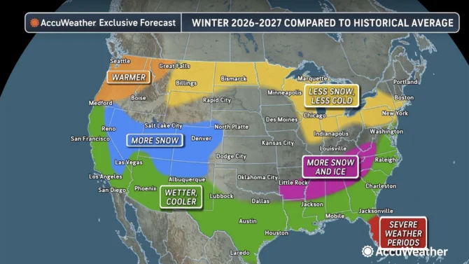
El Niño forecast map shows which states are likely to see the most snow this winter

Things are going to be a little different this winter, thanks to the powerful El Niño. Photo: AccuWeather

This year’s El Niño phenomenon has made waves, that’s the least we can say. It’s historically massive. He will have major consequences on the planet. From droughts to floods to too much or too little snow, we’re gearing up for one hell of a season. A new forecast map shows which states are most likely to see the biggest changes in snowfall this winter. The map was created by AccuWeather.
“A potentially record-breaking El Niño is expected to be the dominant force shaping the 2026-2027 winter, influencing the paths of storms, where snow accumulates, and which areas experience more heat waves than arctic blasts,” AccuWeather wrote.
“This could become the strongest El Niño on record,” said AccuWeather long-range expert Paul Pastelok. Pastelok is almost certain that this event will surpass the powerful El Niño events of 1982-83 and 1997-98.
During the winter months, El Niño intensifies. What typically happens is that the Pacific, from California down to the Gulf Coast, gets a lot more precipitation. In the north, however, these blasts of frigid arctic air are muted, so these regions are experiencing warmer conditions than usual, which may mean less snow. However, this is all very complicated, so it’s almost impossible to know exactly what will happen.
“The El Niño-powered phenomenon may fluctuate throughout the season, as other factors come into play,” AccuWeather wrote. “These influences can temporarily reshape storm tracks and lead to changes in snowfall and temperatures, including occasional cold snaps in areas that are otherwise expected to experience a warmer winter.”
This year is expected to be the opposite of last year, with areas that did not receive heavy snowfall being hit the hardest.
“The snow season is expected to get an early start from the Sierra Nevada through the Great Basin and into the central and southern Rockies, a boon for ski resorts after a poor season last winter,” AccuWeather continued. “A change in storm tracks will also bring snowfall to the Plains in January and February, offsetting infrequent snowfall during the first part of winter. »
As mentioned, however, there is plenty of room for error.
“While we expect below-average snowfall, it only takes one storm to turn things around, especially for East Coast cities,” Pastelok warned. “So that’s something we need to monitor, especially in late January and February.”
In California, it is very likely that atmospheric rivers will flood the region, leading to flooding in the Golden State and lots of snow at higher elevations.
Gn headline