
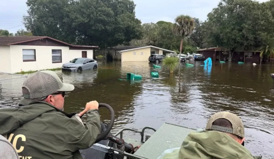
Historic flooding has inundated parts of east-central Florida, with significant river flooding reported near Cocoa and further increases expected northward along the St. Johns River.
The danger is shifting rather than disappearing, as water circulating in the basin could keep rivers rising after the heaviest rains subside.
“We’re very concerned about the St. Johns River,” said Will Ulrich, a warning coordinating meteorologist in Melbourne. Associated Press. “This is just an incredible amount of water that will cause the river to continue to rise over the next few days. »
Learn more on Weather report
Residents in Brevard, Volusia, Lake and Seminole counties are facing flooded homes, impassable roads and prolonged disruptions, while Clay County is also bracing for rising waters.
Scattered showers and isolated storms Saturday could worsen flooding in saturated areas, although forecasters expect generally lighter rain.
Use the map below to explore areas at risk of flooding. Select a color marker for local details; Zoom in with the plus and minus buttons on the desktop or pinch the map on a touchscreen.
Why it matters
Precipitation in the upper St. Johns River has pushed several monitoring points beyond flood stage, creating a slow-moving emergency that could extend well beyond the storm itself.
Unlike flash floods, which can develop and recede quickly, river floods can worsen as runoff moves downstream. That leaves northern communities facing new dangers even as conditions begin to stabilize elsewhere.

Key Points
- The St. Johns River near Cocoa stood at 18.7 feet Friday evening, compared to a flood stage of 16 feet.
- Water near Geneva had reached 11.7 feet and was expected to peak at 13 feet late in the weekend.
- Major flooding was forecast in Deland, Sanford and Astor.
- A flood warning for urban areas and small streams covering northern Brevard and eastern Volusia counties expired at 8 a.m. Saturday after emergency officials reported flooding Friday evening.
- North Fork Black Creek in Middleburg was expected to reach its flood stage of 15 feet Saturday evening.

Brevard County suffers some of the worst damage
One of the most severe river records was recorded west of Cocoa, where the St. Johns surpassed its previous record.
At 17.2 feet, water is entering homes around Poinsett Lake, the Silver Pines subdivision in Rockledge and Cocoa’s Shakespeare Park area, according to the National Weather Service. Friday’s reading was an even higher 1.5 feet.
Access has also become an issue. Providence Road, west of Cocoa, was described as impassable, potentially cutting off properties near Mullet Lane and Bass Road. The docks and parking lot at Lone Cabbage Fish Camp were flooded.
The river was expected to reach nearly 18.8 feet through the weekend and early next week, offering little immediate relief to households already surrounded by water.

Rockledge, Cocoa and Edgewater remain exposed
An urban and small stream flood warning for northern Brevard County and eastern Volusia County expired at 8 a.m. Saturday. Local emergency services had reported flooding on Friday evening, and the waters were expected to recede slowly overnight.
Communities inside the expired warning included Rockledge, Cocoa, Edgewater, Titusville, Daytona Beach, New Smyrna Beach, Port Orange and Ormond Beach. Low-lying roads were closed or impassable in some places, although the heavy rains had stopped.
Further showers could renew the problems in saturated areas on Saturday. The National Weather Service (NWS) said 0.5 to 2 inches could fall in some locations, with higher totals possible locally.
Anyone traveling through the area faces ongoing dangers where standing water persists, as it can obscure the route or make its depth difficult to judge. The NWS advises motorists not to enter flooded streets or drive around barricades.

Lake Harney near record high
Further inland, the Saint-Jean River, above Lake Harney, near Geneva, had already entered a major flood phase and was approaching record flood levels.
At 10.8 feet, water covers portions of State Road 46 near Jungle Road and Prevatt Road.
Secondary roads near the river can contain more than three feet of standing water, while structures and marinas between Harney and Jesup lakes are becoming increasingly vulnerable.
The gauge recorded 11.7 feet at 8:30 p.m. Friday, nearly double its level of six feet (the width of the creek which is the depth at which water fills a main channel to the point of overflowing). The river was expected to crest at nearly 13 feet late this weekend.

Rising waters push the threat north
Sanford has experienced minor flooding, but the river is expected to reach major flood stage by the middle of next week.
At eight feet high, low-lying buildings and marinas around Sanford, Enterprise and Lake Monroe face greater flooding.
Near Deland, the level had climbed to five feet and was expected to reach six feet early next week. Major flooding begins at 5.3 feet, affecting many structures and marinas, including the Hontoon Island area.
Astor faces a longer test. River Road and several small streets become inaccessible during major flooding, with water entering homes along the canals and the main canal. The NWS said levels could take weeks or even months to fall below flood threshold.
The risk extends to Clay County, where North Fork Black Creek in Middleburg is expected to reach minor flood stage Saturday evening, when water could begin entering residential yards near Hawk Haven Road, Lazy Acres Road, Redbug Alley and Enchanted Lane.
Saturday’s forecast confirms that all five St. Johns River watch points covered in this article are experiencing major flooding or expected to reach major flooding stage in the coming days. Any additional rain over the basin could lead to further increases.

What happens next
Updated river forecasts are issued twice daily, with the next detailed readings for all five points on the St. Johns River expected around noon Saturday.
For residents, the practical danger increasingly lies in access: if roads remain passable, emergency vehicles can reach isolated houses and rising waters enter buildings before rivers flood.
Newsweek Reporters and editors used Martyn, our AI assistant, to produce this story. Learn more about Martyn here.
Contact Newsweek’s editor-in-chief for this story: Edward Pearcey.
Gn usa