
Record high tides cause chaos – and kayak travel – across California | California

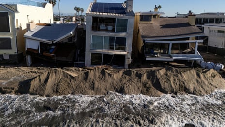
Historic high tides caused chaos along the California coast this week, as parts of the state were inundated by record water levels. Seawater engulfed low-lying communities from San Diego to the San Francisco Bay area, submerging streets, flooding homes and businesses, and blocking important transportation corridors and rail routes.
Kayakers and paddleboarders could be seen Monday and Tuesday on usually busy thoroughfares in Marin County, north of San Francisco. Several drivers had to be rescued from cars floating in the area, while cyclists who attempted to cross the temporary lagoon that formed quickly found themselves waist-deep. Farther south, in towns like Newport Beach, water pounded emergency infrastructure set up to keep seas from swelling, which seeped through berms, seawalls and sandbags blocked along the coastline.
Across the state, all-time records were broken. Near Los Angeles and San Diego, tides exceeded 8 feet. San Francisco recorded its highest figure for the month of October on Wednesday, breaking a record set the day before.
The National Weather Service has issued a series of flood advisories and warnings that will last for several days. In San Diego and Orange counties, forecasters said significant coastal flooding was expected during high tides through Thursday. “Many roads may be closed. Low-lying properties, including homes, businesses and some critical infrastructure, will be flooded,” they said Wednesday. In Los Angeles, moderate flooding risks continued into the weekend, although tides would begin to recede after Thursday. Shoreline erosion is expected across the California coast.
Repeated onslaughts from rising waters have resulted in a tumultuous fall, particularly in Southern California, which has been hammered repeatedly over the past two months. Los Angeles has already recorded 12 days of coastal flooding in 2026, according to records from the National Oceanic and Atmospheric Administration (Noaa) – surpassing any year in the last 50 – with months remaining.
But the dangers will not recede with the tides, and the new records will not last long. The worst flooding could come amid severe impacts from an unusually strong and still strengthening El Niño in the coming months, experts warn, with the potential to raise tides several feet above levels recorded this week.
“What we are seeing now could be the start of what could be much more disruptive conditions later this year,” climate scientist Daniel Swain said during an online press briefing on Tuesday.
The sharp rise in sea levels is the result of thermal expansion from a record-breaking ocean heat wave that was superimposed on higher sea levels and is fueled by the human-caused climate crisis, Swain said. A trapped coastal Kelvin wave — a huge underwater band of warm water that has crept across the Pacific and along the North American coastline — has also added to the fray, and the California coast could see a lot more during the winter and early next year. “I would expect these water levels to be exceeded several times this winter,” Swain said.
San Diego, La Jolla, Los Angeles and Santa Monica all have a greater than 80% chance of flooding during high tide in December, according to the Noaa outlook. Most stations near coastal communities as far north as the Canadian border were in the 60-80% category.
The flooding seen this week was not what is known as king tides, which are the highest tides expected for the year. These will appear just in time for the busy holiday weekends, around Thanksgiving and Christmas this year, and between January 20 and 23 next year.
King tides can add an additional foot or two to water levels, which are already about a foot high due to human-caused warming, El Niño effects and Kelvin waves. If each of these layers aligns as predicted, they will create up to 5 feet of sea level rise above average, in several places at once.
“We’re in extreme territory — and really record territory,” Swain said. This would set the stage for disastrous flooding if a storm arrives when waters are high. Swain said that’s when things “got really tough.”
The historic El Niño brewing in the Pacific has the power to trigger extreme weather around the world, and in California, that could mean supercharged storms. Southern California is particularly prone to flooding during El Niño events, and this year the weather phenomenon, characterized by warmer-than-average equatorial sea surface temperatures, could have an extraordinary impact.
If a strong storm occurs during the windows when the tides are highest, flooding could be disastrous. “There’s at least a 30 to 40 percent chance we’ll stack all of this this winter, and potentially more than once,” Swain said.
Gn headline