
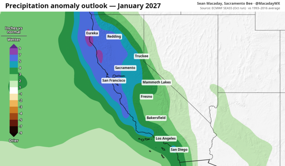

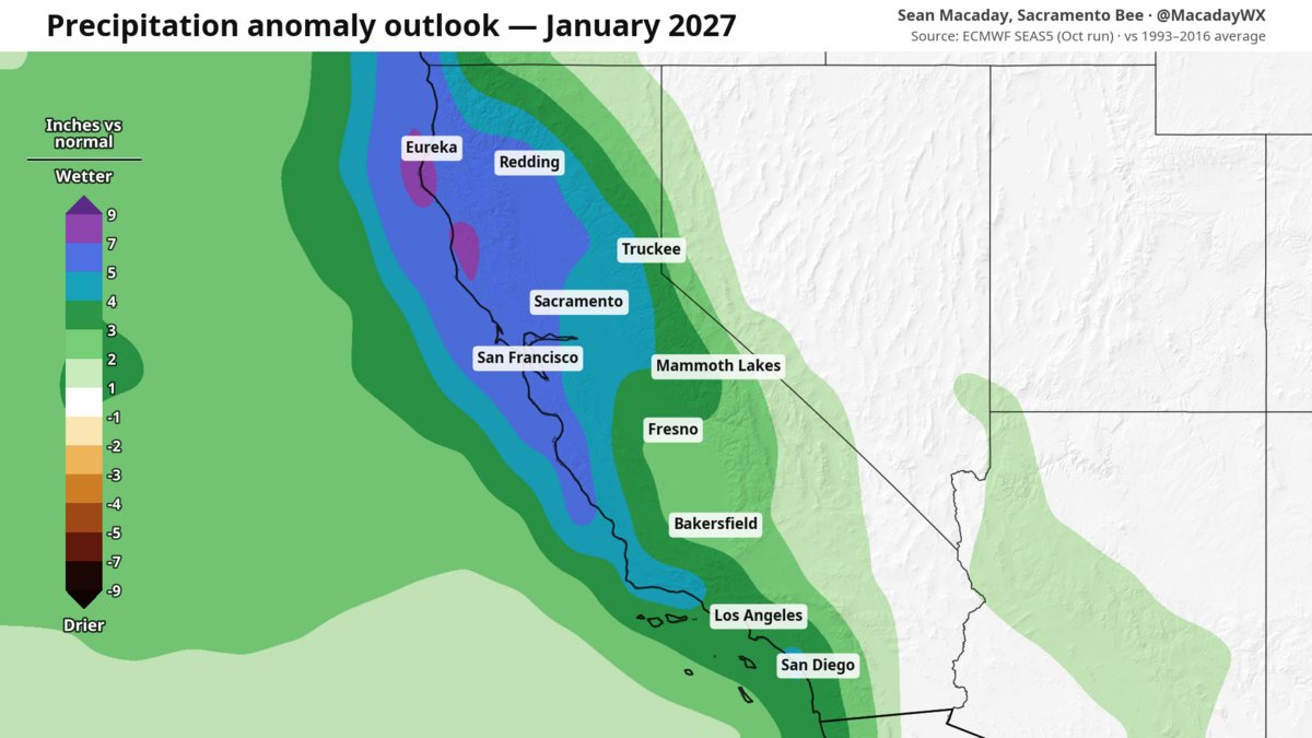
The European Seasonal Forecast System 5 (SEAS5) forecasts above-average precipitation across California for the month of January.
The Sacramento Bee, ECMWF SEAS5
As El Niño breaks records week after week, a new set of data points to a wetter winter for the entire state of California, even wetter than previously thought.
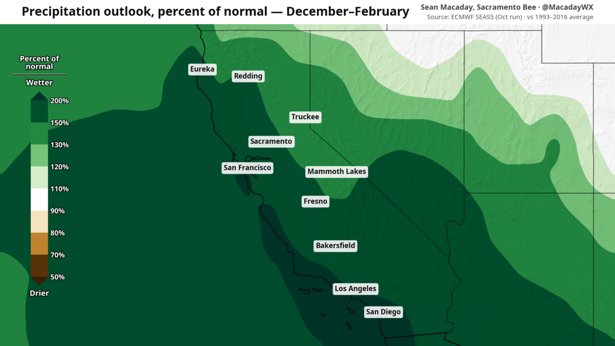
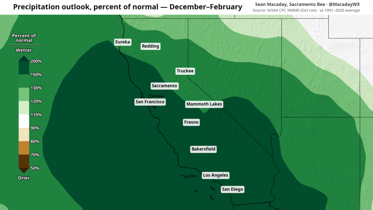
New this week, two new sets of climate model products have been released, and both indicate rain and snow on the way. The National Multi-Model Ensemble (NMME), which we highlighted as one of the main signs of a wet winter earlier this week, and the European Seasonal Forecast System 5 (SEAS5), which has been found to be more accurate than others in the western United States.
The sign is quite clear, rain is coming, and in places much more.
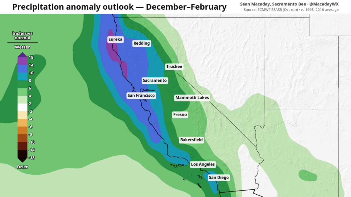
.png "precip_pct_djf_seas5_oct_ca (1).png")
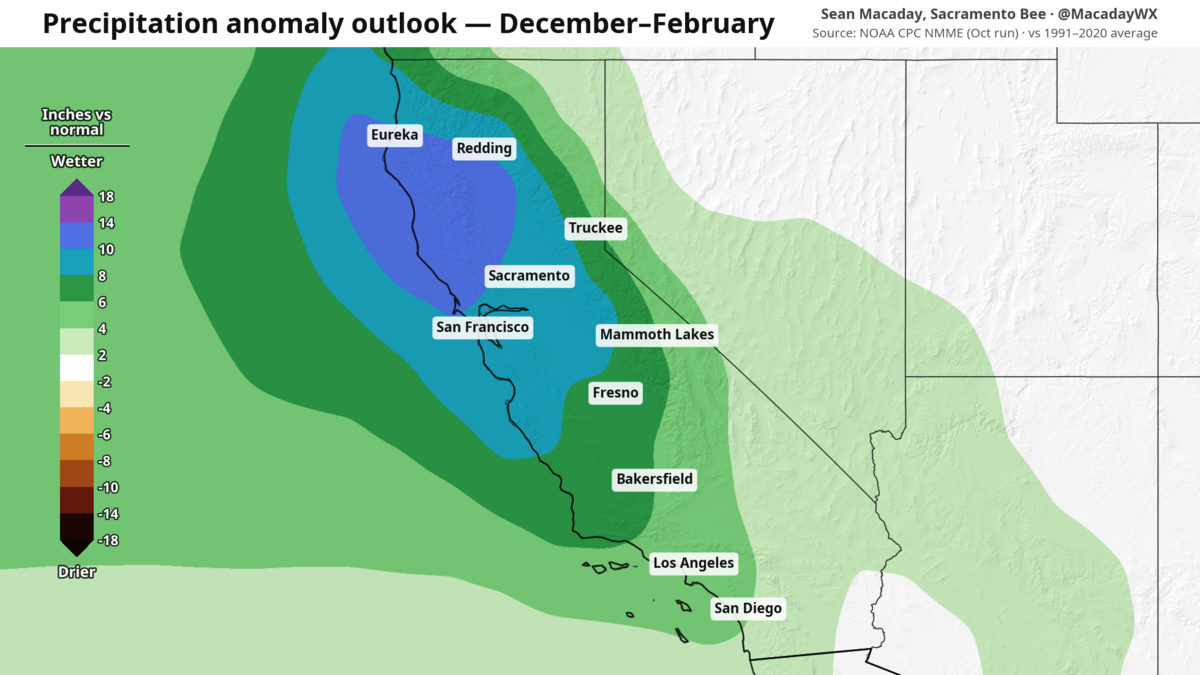
.png "precip_pct_djf_nmme_oct_ca (1).png")
Most of the state and the vast majority of populated areas appear poised to receive precipitation of at least 150% of normal throughout the winter months, with some areas likely receiving double their winter average along the coast, where El Niño is already expected to raise sea levels thanks to warmer ocean temperatures and an ongoing marine heatwave.
This isn’t limited to Southern California, either. The strongest rain signal extends from Sacramento and the Bay Area south to San Diego, with the strongest above-average signal extending statewide and into Nevada and southern Oregon.
The numbers become even more stark when you consider what “normal” is for any location. Consider that Sacramento typically receives about 11 inches of rain in December, January and February. The data here indicates this winter will be 16 to 18 inches. San Francisco normally sees 15 inches and this winter, 24 to 28 inches. Fresno is typically much drier at 5.5 inches, but here it would be closer at 9 inches. Farther south, Los Angeles and San Luis Obispo each see about 10 inches in a given winter. This data would double approximately – 20 inches.
The most intense raw amounts appear to be along the northern coast mountains, where warm coastal waters collide with steep terrain. Widespread winter totals of 30+ inches are a decent bet here.
Of course, reality is never exactly what a climate model describes. Climate models examine trends on a global scale. Not at a given time or day, but over weeks and months to identify overall trends. They have real skills and are not the same as the weather models on your phone that predict rain.
This means that the rain that falls won’t be as gentle. Precipitation forecast will be erratic, characterized by strong gusts alternating with dry periods rather than regular, continuous drizzle. Showers and atmospheric rivers will cluster together to produce more moisture in some areas and less in others. This trend will likely be even more pronounced over hilly terrain, where some rainfall totals could approach extremes.
This is a steady increase in numbers from early August, when rainfall appeared high across the state, but not to the degree expected for some areas that could see more than double the typical winter precipitation.
Snow in the mountains also seems abundant, especially in January
Despite a warmer-than-expected winter due to El Niño, snow will still fall at higher altitudes.
By adapting the new European climate data to the terrain, a clear picture emerges: a little less snow in the foothills, but significantly more snow at altitude. This is especially true for the Klamath Mountains and Sierra.
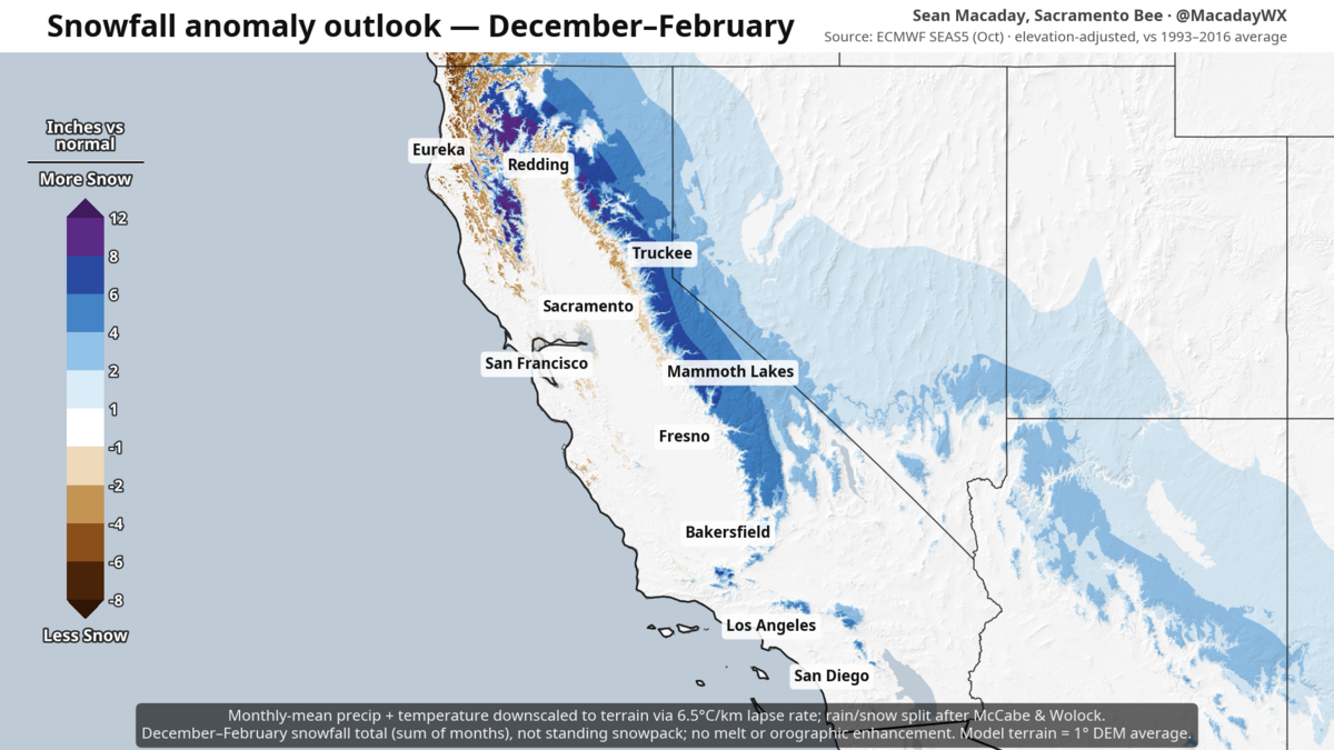.png "snow_djf_seas5_oct_ca (1).png")
Just like rain, snowfall will not be regular. Expect this trend to potentially be greatly amplified along mountain peaks and ridges, even in parts of Southern California.
The rainiest and snowiest month in the entire state is without a doubt January.
El Niño still not slowing down and could persist longer
The latest European climate data shows a worrying sign: El Niño could last longer than expected.
Previous estimates placed the peak of El Niño heat in November, but a picture of a longer-lasting event is emerging, showing the peak coming later in December, with irregular warm spells persisting through March and, realistically, through April and May. This is likely to extend the wet trend into spring.
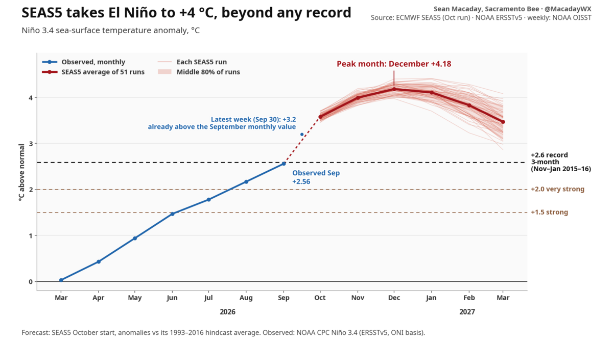
This El Niño is already the strongest and most eastern localized event of its type on record at this point in the year. Both of these factors are good predictors of increased precipitation in California and the southeastern United States.
The next round of weather products won’t occur until November, by which time El Niño rains could already start sneaking into Southern California.

Sean Macaday
The Sacramento Bee
Sean Macaday covers weather for McClatchy Media in California. Originally from Chicago, Sean worked covering weather for local television in Minnesota for 6 years. He holds a bachelor’s degree in meteorology and marine science from the University of Miami.
Gn headline