
The Earth, a deformed sphere according to NASA? Confusion around a representation of the globe

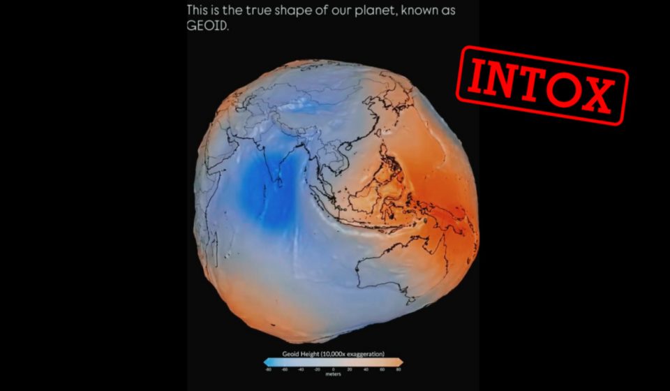
“NASA has shown the ‘true shape’ of the Earth, and the planet looks like a misshapen potato”: at the beginning of August, several general knowledge pages on Facebook began to misleadingly relay a representation of the globe broadcast by the American space agency in mid-July.
The Earth thus presented has the shape of a dented sphere, with areas of the planet that stand out strongly while other regions are squashed, far from the spherical shape generally depicted.
“This is the true shape of our planet”, describes another page on Facebook, the video of which has been viewed more than 400,000 times.
The “geoid”, the “most faithful” representation of the Earth…
But what did NASA actually show? The American space agency has actually published on July 15 a representation of the Earth in the form of a “geoid”.
According to the site from NASA, the geoid is a mathematical model which “represents the shape that the surface of an ocean would take under the effect of the Earth’s gravitational field”. Because the Earth does not have a uniform density: gravity is stronger where the mass is greater, the planet thus presents irregularities where there are, for example, high mountains or large bodies of water.
“The geoid is the true shape of the Earth, but without its reliefs,” adds Nicolas Lambert, research engineer at the CNRS at the Center for Spatial Analysis and Geovisualization (RIATE), contacted by our editorial staff. In short, it represents the shape that the surface would have with the sole influence of gravity and rotation.
Ordinarily, the Earth is often presented in spherical form. However, scientists have discovered since the end of the 17th century that the globe is actually what we call an ellipsoid, being slightly flattened at the poles and bulging at the equator.
But scientists consider that this ellipsoid shape no longer accurately reflects the physical shape of the Earth, whose surface is very irregular. With the advance of knowledge since the end of the 19th century, it is now the geoid which is “the most faithful representation of the ‘physical form’ of the Earth”, as indicated by a article from the National Institute of Geographic and Forestry Information published in April 2026.
…but a deliberately “exaggerated” visualization by NASA
The new measurements published in July by NASA, which relied on more than a billion observations over a period of 15 years from 19 satellites, thus give an extremely fine version of this geoid.
But despite this degree of precision, confusion has arisen from the way the geoid is generally represented. “To correctly visualize a geoid, we exaggerate the deformations. Otherwise, we would only see a ball,” explains Nicolas Lambert.
The representation of the geoid published by NASA on July 15 was thus deliberately “exaggerated” in order to highlight the regions most affected by gravity. Without taking relief into account, the gap between the highest and lowest point is only 191 meters, and is therefore difficult to see on a scale visualization. NASA therefore chooses to represent the geoid by exaggerating these shifts by multiplying the effect of gravity by 10,000 to better explain the principles of this modeling.
If NASA had explained on its site in mid-July that this version of the deformed Earth was “greatly exaggerated”, the American space agency had to update its page at the end of July to clarify that this shape was not “not to scale“.
The agency even published in its update a visualization of the geoid on scale, on which this time we cannot discern with the naked eye the irregularities of the Earth linked to gravity.

On the left, the Earth presented in the form of a geoid on a 1:1 scale published by NASA. On the right, the Earth presented in geoid form and “exaggerated” to a scale of 1:10,000. The legend clearly states that this visualization is “not to scale”. © NASA
A confusion still viral
In a explanatory video on August 11, aiming to put an end to the confusion, she recalled that the geoid is “a mathematical model of the Earth’s gravitational field, and not its real form”, which highlights these irregularities due to gravity.
NASA specifies that “scientists use the geoid to study Earth’s gravitational field and how it changes as mass moves around our planet.” Information “essential for navigation, both on the ground and in space”.
Before concluding: “in summary, no, the Earth is not shaped like a lumpy potato. It is essentially a sphere. But the geoid is quite lumpy, especially if we enlarge it.” A welcome clarification, even if some confusion still reigns: on September 1, several local media in France from the EBRA press group fueled this confusion by sharing the same video claiming that NASA’s exaggerated visualization showed “the true surface of the Earth”, specifying only in the caption that the scale was accentuated.

The same video was shared by media outlets from the EBRA group on September 1, which claims that the exaggerated depiction of the globe represents “the true surface of the Earth.” You have to read the caption to understand that this representation is in reality an exaggerated version. © L’Est Républicain / Le Bien Public / Vaucluse Matin.