

After what was the hottest September on record across much of Texas, conditions finally cooled down in recent days. In San Antonio, temperatures hovered in the 70s and low 80s throughout the weekend — much more comfortable than the 90s and triple-digit temperatures that have hit the region in recent weeks.
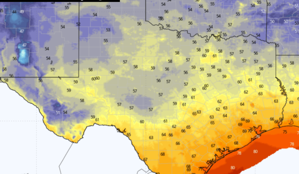
Heading into Monday evening, conditions will look even more like a fall across Texas as temperatures drop into the 50s and 60s across the state. Northerly winds will also send much drier air into the region, allowing humidity levels to drop significantly.
That said, forecast models show rain could return to the region by the end of the week as a Gulf disturbance moves onshore. Here’s a preview of what to expect this week.
Comfortable conditions are expected in San Antonio early Monday, as temperatures will remain in the low 70s until 9 a.m. Skies will be mostly clear, but winds will remain breezy, coming from the north at 15 to 20 mph.
With drier air and more sunshine expected on Monday, temperatures will warm more than during the weekend. San Antonio is expected to reach 80 degrees by midday, with high temperatures reaching the mid-80s by late afternoon. No rain is expected in the region.
Overnight and early Tuesday morning, many people across Texas may want to break out a sweater or light jacket as temperatures are expected to drop to their lowest levels in more than four months.
In San Antonio, temperatures will hover in the 70s by 10 p.m., finally falling into the 60s after midnight. Overnight minimum temperatures across the metro area are expected to reach 66 to 68 degrees – the region’s lowest temperatures since May 28.
Areas further north in Texas will be even cooler. In the Hill Country, minimum temperatures are expected to approach 60 degrees in Kerrville and Fredericksburg, while temperatures will likely drop into the 50s in large parts of North Texas, West Texas and the Panhandle.
Plenty of sunshine is expected through mid-week as dry air remains in place. This will cause afternoon high temperatures to rise a few degrees, reaching the upper 80s on Tuesday before potentially reaching 90 degrees again by Wednesday. Low temperatures will remain cool, with values still expected to drop into the mid to 60s each morning.
By Thursday, Gulf humidity is expected to increase across South Texas, leading to more cloud cover and a slight (20%) chance of showers and storms late this afternoon and evening. Humidity will continue to increase Friday, allowing rain chances to reach around 40% in San Antonio. Additional cloud cover will bring high temperatures back to the mid 80s.
There is some potential for a tropical system to develop in the Gulf during the middle to second half of the week. The overall chance of rain in San Antonio will depend heavily on the eventual path and strength of the Gulf disturbance. Be sure to stay at expressnews.com/weather for updates.
Gn usa