
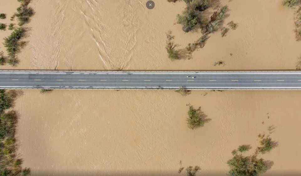

Torrential rains and flooding in the Four Corners region have caused more than a dozen emergency road closures in recent days, crippling transportation access for some rural communities.
Southwest Colorado is a remote part of the state where individual roads are sometimes the main, or even only, connection between communities and detours are measured in hours, not minutes. Three major closures, two on US 160 and one on Colorado 151, remain in effect Monday. Officials encourage commuters and travelers to check conditions before hitting the road and to expect detours and delays.
Southwest Colorado has no highways, said Lisa Schwantes, a spokeswoman for the Colorado Department of Transportation. She lives in Durango, one of the communities affected by the flooding.
“The U.S. and state highways are certainly lifelines to all rural communities in Colorado,” she said.
The storm, a remnant of Hurricane Trudy in the Pacific Ocean, swept through the region, dropping up to 7 inches of rain in some areas. This water overwhelmed streams and rivers, tearing up road shoulders and culverts.
Colorado 151 was completely destroyed by floodwaters. It’s a critical corridor for people commuting between places like Ignacio, Tiffany, Allison and Pagosa Springs, Schwantes said.
Flooding swept away major arteries bordering the bluffs, such as US 550 over Red Mountain Pass and US 160 over Wolf Creek Pass. Wolf Creek Pass, which is closed indefinitely, typically sees between 2,700 and 3,400 vehicles per day.
When Wolf Creek Pass is closed, “travelers are forced to take an alternate route through New Mexico,” Schwantes said. “It will add a few hours to their journey.”
Maintenance workers, engineers and hydrologists have responded to emergency incidents on several area highways since the storm began Wednesday evening, CDOT said in a statement Sunday.
Drivers should avoid traveling during flood warnings and watches if possible and be aware that streams and rivers will continue to rise even after rainstorms pass.
Some roads have reopened since flooding peaked on Thursday and Friday, although travelers should still expect delays. These include US 160 west of Pagosa Springs, US 550 over Red Mountain Pass, US 285 north of Monte Vista, Colorado 112 from Del Norte to Central, and Colorado 17 from Antonito to the Colorado-New Mexico border.
If detour routes are suggested through neighboring states, check local road conditions by visiting NMroads.com, AZ511.gov and udottraffic.utah.gov.
Major road closures with no end date
US 160, the main traffic corridor through parts of southwest Colorado, is closed for more than 30 miles from Pagosa Springs, through Wolf Creek Pass to the South Fork. The flooding caused a culvert north of Pagosa Springs to rupture, which then caused a sinkhole to form on the road.
Near the South Fork, the flood undercut the road and caused damage to the shoulder. It also damaged a retaining wall under the highway near the pass scenic overlook, as well as an emergency exit ramp for tractor-trailers.
It is unclear when the highway will reopen, the CDOT statement said.
“We are certainly aware that this is a critical route and we need to open it as quickly as possible,” Schwantes said, “but we also need to ensure that it is safe for travel.”
US 160 is also closed for 18 miles around the San Juan River Bridge near Four Corners and the Colorado-New Mexico border. The San Juan River has almost reached the base of the bridge and inspectors are still evaluating it to make sure it is safe.
This closure impacts travel between Cortez and Teec Nos Pos, Arizona, and traffic will be rerouted through Cortez and Monticello, Utah. Colorado 41 between Cortez and Bluff is not an alternate route due to flooding impacts, CDOT said.
Colorado 151, which runs from Antonito to Chama, New Mexico, is closed for about 12 miles south of Chimney Rock.
Floodwaters washed out a segment of the road about 7 miles south of the intersection with U.S. 160. Local residents should not use county or secondary roads to access the road closure area, CDOT said. The Transportation Department is planning emergency repairs and a temporary access road.
How to travel safely
CDOT has advised against traveling during flood watches and warnings, telling motorists to never drive through a flooded area.
“You don’t know how deep or how fast the water is flowing,” CDOT said.
Water can cause a mid-sized car to float when it reaches a depth of 8 to 10 inches, increasing the risk of being swept off the road. Driving too fast on wet roads or through flooded areas can also cause vehicles to hydroplane.
Any amount of flooding or mud can clog the roadway and make it difficult for drivers to know exactly where to drive. Water and mud can also hide rocks, branches and other debris. If the road is not visible, wait until the water calms.
“Never use your cruise control in rainy weather with standing water on the roadway,” CDOT said.
Travelers should ensure their vehicles have an emergency kit containing water, snacks, a flashlight and a blanket, as well as pet supplies and children’s activities, if applicable.
Gn usa